About Banks Vernonia State Trail Offline Map, Oregon
Offline map and trail guide for the Banks Vernonia State Trail in Oregon. Fully interactive map complete with entire trail by segment between official parking areas, GPS location, and elevation profiles. The Banks...
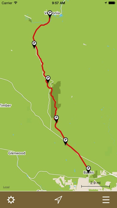
Offline map and trail guide for the Banks Vernonia State Trail in Oregon. Fully interactive map complete with entire trail by segment between official parking areas, GPS location, and elevation profiles. The Banks Vernonia State Trail is a paved rail trail and state park in Northwest Oregon. It runs for 21 miles (34 km), primarily north south, between the towns of Vernonia in Columbia County and Banks in Washington County on an abandoned railroad bed. Banks is about 25 miles (40 km) west of Portland. Cell phone coverage along the Banks Vernonia State Trail is spotty. Our app solves this problem! Once the map is downloaded, you re free to explore the entire trail without a network connection and always know exactly where you are. FEATURES: Simple, easy-to-use interface. Fully interactive offline map. GPS location shown on map. Navigate the trail in its entirety. Turn trail segments on/off between official parking areas Interactive elevation profiles. Trail segment lengths. Parking locations shown on map. Open parking locations in Apple Maps for driving directions General park information. Note: The Banks Vernonia State Trail app is designed for the iPhone. Although it can be installed on GPS-enabled iPads (iPads with Wi-Fi + Cellular), it s not formatted for the larger iPad screen - it runs doubled like all other iPhone apps. Proudly made in Banks Oregon by Scott D. Smith. I sincerely hope you like it!
Requires iOS 8.0 or later. Compatible with iPhone, iPad 2 Wi-Fi + 3G, iPad Wi-Fi + Cellular (3rd generation), iPad Wi-Fi + Cellular (4th generation), iPad mini Wi-Fi + Cellular, iPad Air Wi-Fi + Cellular, iPad mini 2 Wi-Fi + Cellular, iPad Air 2 Wi-Fi + Cellular, iPad mini 3 Wi-Fi + Cellular, iPad mini 4 Wi-Fi + Cellular, 12.9-inch iPad Pro Wi-Fi + Cellular, and 9.7-inch iPad Pro Wi-Fi + Cellular.
Previous Versions
Here you can find the changelog of Banks Vernonia State Trail Offline Map, Oregon since it was posted on our website on 2016-09-30 04:05:39.
The latest version is 1.0 and it was updated on 2024-04-22 20:34:41. See below the changes in each version.
Banks Vernonia State Trail Offline Map, Oregon version 1.0
Updated At: 2015-05-30
Disclaimer
Official App Store Link
We do not host Banks Vernonia State Trail Offline Map, Oregon on our servers. We did not scan it for viruses, adware, spyware or other type of malware. This app is hosted by Apple and passed their terms and conditions to be listed there. We recommend caution when installing it.
The App Store link for Banks Vernonia State Trail Offline Map, Oregon is provided to you by apps112.com without any warranties, representations or guarantees of any kind, so access it at your own risk.
If you have questions regarding this particular app contact the publisher directly. For questions about the functionalities of apps112.com contact us.